project logo OSGeo Project

deegree

Web Services

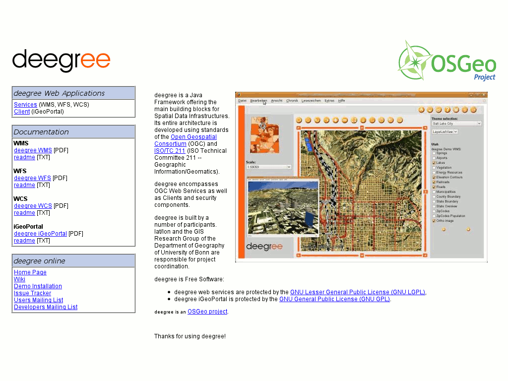
deegree is free, stable, powerful and easy to use. deegree is the most comprehensive set of implementations of Open Geospatial Consortium (OGC) standards in free and open source software, ranging from a transactional Web Feature Service to three-dimensional data display through a Web Terrain Service and many more!

deegree is a solution for web- and desktop-based Geographic Information Systems (GIS) and Spatial Data Infrastructures (SDI). It is comprised of a comprehensive yet powerful Java Application Programming Interface (API) and a powerful object-relational mapping for simple and complex spatial schemas. deegree also provides a set of standards-compliant webservices for web mapping, feature and catalogue services as well as sensor and processing services.

deegree gets your SDI up and running, using your own data and fulfilling your requirements.

project logo

Some example features

  • Web Map Service

    • very flexible concerning layer contents
    • supports and uses style definitions (SLD 1.0)
    • thematic mapping capabilities through charts (pie, bar, line) as point symbolizers
    • datasources: all common OGC web services (WMS, WFS, WCS), PostgreSQL/PostGIS, Oracle Spatial, any arbitrary SQL statements can be used to create the WMS layer content
    • very stable, even for large scales
    • supports HTTP GET, HTTP POST and feature info requests
    • certified to be OGC compliant
  • Web Feature Service

    • supports simple and complex features
    • on the fly coordinate transformation for more than 3000 coordinate reference systems
    • supports flexible output formats
    • easily enhanced to support INSPIRE directive
  • Web Coverage Service

    • supports HTTP GET and HTTP POST requests
    • datasources: images (tif, png, jpeg, gif, bmp); GeoTIFF; ECW files; Oracle GeoRaster
    • high-speed access to large coverages
  • Catalogue Service-Web

    • datasources: PostgreSQL-Database; Oracle-Database
    • supported requests: GetCapabilities; DescribeRecord; GetRecordById; GetRecords; Transaction - Insert, Update, Delete; Harvesting
  • Web Map Print Service

    • supports different print formats (HTML, PDF, PNG)
    • long time running jobs
    • supports asynchronous requests to enable large-scale plots
    • requests are stored within a database and will be available even if WMPS is stopped by an administrator or the machine fails
  • Web Perspective View Service

    • datasources: remote/local-WMS, remote/local-WFS, local-WCS, Postgres/PostGIS, Oracle Spatial
    • elevation models can be vector data or raster data
    • requests: Get3DFeatureInfo, GetView

Implemented Standards

  • OGC Web Map Service (WMS) 1.1.0*, 1.1.1, 1.3.0*
  • OGC Web Feature Service (WFS) 1.0.0, 1.1.0 (2.0 in progress)
  • OGC Web Coverage Service (WCS) 1.0.0* (1.1.0 in progress)
  • OGC Catalogue Service-Web (CSW) 2.0.0, 2.0.1, 2.0.2; including OGC ISOAP 1.0 and INSPIRE profile
  • OGC Web Perspective View Service (WPVS) Draft 6
  • OGC Web Coordinate Transformation Service (WCTS) 0.4.0
  • OGC Web Processing Service (WPS) 0.4.0, 1.0.0
  • OGC Sensor Observation Service (SOS) 1.0.0

Details

Website: http://deegree.org

Licence: LGPL

Software Version: 2.3

Supported Platforms: Windows, Linux

API Interfaces: Java

Support: http://wiki.deegree.org/deegreeWiki/GettingSupport